


Garmin echoMAP CHIRP 44CV 4.3-inch Chartplotter Fishfinder Preloaded BlueChart® g2 HD U.S.
Model: 010-01797-01UPC: 753759176044
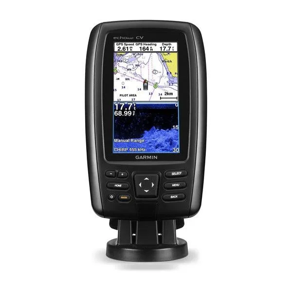
- 4.3-inch color display with keypad control
- Includes transducer with CHIRP (77/200 kHz) and CHIRP ClearVü (455/800 kHz, 500 W)
- Preloaded BlueChart® g2 HD charts for the coastal U.S.
- Includes Quickdraw Contours custom HD map creation software
- Internal 5 Hz GPS updates position and heading 5 times per second
It’s time you started fishing with the power of CHIRP sonar. The easy-to-install, easy-to-use 4.3-inch echoMAP CHIRP 44cv chartplotter includes transducer for high wide CHIRP sonar and Garmin CHIRP ClearVü for clear scanning sonar images. It includes Quickdraw Contours software to instantly create your very own HD maps with 1-foot contours as you fish. Internal 5 Hz GPS updates position and heading 5 times per second. Cords plug directly into the mount, allowing you to quickly install and remove your device from power and mount. Transom and trolling motor mounts included.
The built-in sonar capabilities of echoMAP 44cv include CHIRP sonar, the most sophisticated sonar technology available for the fishing and boating public. CHIRP sonar provides amazingly clear target separation and definition because it puts even more energy onto the target than traditional sonar. It also includes sonar-recording capability that coordinates the timing of the sonar return with your boat's position and saves digital information for playback on a computer using HomePort™ planning software. Use the user data sharing cable to share waypoints and routes between multiple devices.
Garmin ClearVü scanning sonar gives you a nearly photographic, wide image of what passes below your boat. You clearly see structure, submerged objects and fish. Traditional Garmin HD-ID™ sonar and ClearVü scanning sonar are combined into 1 transducer. Also provides HD-ID support for Minn Kota® and MotorGuide® trolling motors with integrated transducers.
echoMAP CHIRP 44cv is preloaded with BlueChart g2 HD maps covering the coastal U.S. (East Coast, West Coast, Gulf of Mexico, U.S. and Canadian sides of the Great Lakes). It also includes all U.S. charts for the entire coastline as well as everything available on NOAA charts. In addition to the basic charts, tidal stations, currents, depth contours, IALA symbols and included fishing charts, BlueChart g2 HD offers smooth transitioning between zoom levels and more seamless continuity across chart boundaries. Customize your screens with Shallow Water Shading, which allows you to contour shade for all depth contours shallower than what you determine is your safe depth. Fishing charts emphasize bathymetric contours with less visual clutter on the display. And there’s also a choice of standard 2-D direct overhead or 3-D "over-the-bow" map views for easier chart reading and orientation.
Instantly create personalized HD fishing maps onscreen with 1-foot contours. Tailor them to fit your needs. These are your maps — you own them. Keep the data to yourself, or share it with the Quickdraw Community on Garmin Connect™.
Fast, responsive 5 Hz GPS and GLONASS refreshes your position and heading 5 times each second to make your movement on the screen more fluid. Now it’s quick and easy to drop up to 5,000 accurate waypoints and find your way back to your secret fishing hot spots.
When you’re off the water, it’s easy to keep your echoMAP CHIRP safe and secure. You don’t have to mess with plugging and unplugging wires from the unit because the cords plug directly into the mount. This allows you to quickly install and remove your echoMAP CHIRP from power and the mount.
A single microSD™ card slot provides expandable memory for accessory map purchases, such as LakeVü HD Ultra with Max Def Lakes or BlueChart® g2 Vision® HD, which adds Garmin patented Auto Guidance and other great features.
If you have waypoints, tracks or frequently used routes stored on another manufacturer’s GPS product - or on a Garmin handheld device - it’s easy to transfer those items to your new Garmin chartplotter via industry-standard GPX software formatting.
Specifications| Physical & Performance | |
| Dimensions | 4.0"" x 6.6"" x 1.8"" (10.2 x 16.8 x 4.6 cm) |
| Display size | 2.1"" x 3.7""; 4.3"" diagonal |
| Display resolution | 480 x 272 |
| Display type | WQVGA display |
| Water rating | IPX7 |
| Antenna | Internal |
| NMEA 0183 compatible | Yes |
| Garmin Marine Network™ ports | None |
| Maps & Memory | |
| Prelaoded maps | BlueChart® g2 (coastal maps) |
| Accepts data cards | 1 microSD™ card |
| Waypoints | 5,000 |
| Routes | 10 |
| Track log | 50,000 points; 50 saved tracks |
| Chartplotter Features | |
| Garmin Sonar compatible | Yes |
| Supports AIS (tracks target ships position) | Yes |
| Supports DSC (displays position data from DSC-capable VHF radio) | Yes |
| Tide tables | Yes |
| BlueChart® Mobile (planning) compatible | No |
| Sonar Features & Specifications | |
| Dual-frequency (50/200 kHz) sonar capable | Yes |
| Dual-beam (77/200 kHz) sonar capable | Yes |
| Frequencies supported | CHIRP (low, mid, high) Traditional: 50/77/200 kHz ClearVü: 260/455/800 kHz |
| Transmit power | 500 W (RMS) / 4,000 W (peak to peak) |
| CHIRP sonar technology | Yes (Built-in) |
| ClearVü | Yes with CHIRP (built-in) |
| SideVü | No |
| Maximum depth | 2,300 ft @ 77 kHz, freshwater 1,100 ft @ 77 kHz, saltwater (depth capacity is dependent on water bottom type and other water conditions) |
| Bottom lock (shows return from the bottom up) | Yes |
| Water temperature log and graph | Yes |
| Sonar recording | Yes |
| Sonar history rewind | Yes |
| Connections | |
| Transducer pin numbers | 4 |
| NMEA 0183 input ports | 1 |
| NMEA 0183 output ports | 1 |
| Video input ports | None |
| Video output ports | None |
| Wireless connectivity | No |
What's in the Box:
- echoMAP CHIRP 44cv with U.S. BlueChart® g2 HD
- Power/data cable
- Tilt/swivel mount
- Transducer (4-pin)
- Transom mount
- Trolling motor mount
- Hardware
- Documentation

 SDHC Card in Polycarbonate Carrying Case with BlueProton Lanyard (Refurbished)")


 Clone Duplicator/Sanitizer - High Speed (300MB/sec) (SYS3011CO)")


